


野外采集与面积测量专家:高灵敏度新世代双星(GPS+GLONASS)快速定位能力、超过48颗卫星为您服务、多种坐标系统与格式转换、 专业面积测亩功能、重量轻又省电、坚固三防设计。
【1】 双星接收:可同时接收GPS和GLONASS两大卫星系统,定位更快更准。
【2】 面积测绘:提供多种测量面积的类型,精准面积和长度测量与实时显示,并具备中途暂停及开关机仍可接续测量功能。
【3】 航迹测量:测量使用者持设备行走轨迹所围成区域的面积(起终点以直线连接)。
【4】 航线测量:使用者创建一条航线,来计算该航线所围成区域的面积。
【5】 等宽测量:依据使用者所输入固定宽度,结合手持设备所行走的轨迹来计算面积(宽度乘以轨迹长度)。
【6】 坐标系统:具备北京54,西安80和CGCS2000等坐标系统与显示格式。
【7】 航迹记录:时间间隔、距离间隔、自动等多种航迹记录模式,满足不同条件下的各种需求。
【8】 低耗电量:两节5号电池,可持续使用25小时以上(较传统产品省电50%)。

标准配置: 1.Etrex10 主机 2.腕绳 3.使用说明书 |
||||||||||||||||||||||||||||||||||||||||||||||||||||||||||||||||||||||||||||||||
GARMIN eTrex 10
- 2.2” (diagonal), monochrome, sunlight-readable display
- Waterproof to IPX7 standard
- up to 25 hours on 2 AA batteries
- Paperless Geocaching
- Can hold 2000 geocaches
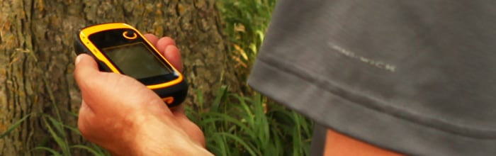
Only Garmin could make the eTrex better. The new eTrex 10 retains the core functionality, rugged construction, affordability and long battery life that made eTrex the most dependable GPS device available. We improved the user interface and added a worldwide basemap, paperless geocaching and added support for spine mounting accessories. You’ll recognise the name. You’ll recognise the quality. But the eTrex 10 is an entirely new device – a device that only Garmin could offer.
See The Way
eTrex 10 has an enhanced 2.2 in monochrome display that’s easy to read in any lighting situation. Its easy-to-use interface means you’ll spend more time enjoying the outdoors and less time searching for information. Both durable and waterproof, eTrex 10 features the legendary toughness that’s built to withstand the elements – be it dust, dirt, humidity or water, none of which are a match for this legendary navigator.
Find Fun
eTrex 10 features paperless geocaching by supporting GPX files for downloading geocaches and details straight to your unit. Visit OpenCaching.com to start your geocaching adventure. By going paperless, you're not only helping the environment but also making your geocaching more fun. eTrex 10 stores and displays all the information you need, including location, terrain, difficulty, hints and descrtptions, which means no more manually entering coordinates and paper print outs. Simply upload the geocache to your unit and start hunting for caches.


